 PC-07357
 1999
![]() PC-07357
PC-07357
1999

|
|
|
The first in a series of four publications on Natural Shoreland Landscaping and Revegetation |
Undeveloped shorelands, with woods, meadows, and marshy shores, enhance the quality of lakes by providing fish and wildlife habitat and protecting water quality. A buffer of natural vegetation protects the shoreline from bank erosion and helps prevent sediment and nutrients (especially nitrogen and phosphorus) from washing into the lake. Nutrients trigger algal blooms that decrease water clarity. Plants growing in the water provide shelter for young fish, such as bass, sunfish, and yellow perch; without aquatic plants there will be fewer fish. Clearing shoreland vegetation during property development reduces food and cover for animals such as birds, turtles, frogs, and deer. Most owners want to add to the enjoyment of their property as they develop newly-acquired lakeshore, but instead diminish it by landscaping in a way that increases maintenance time and decreases lake quality. When you replace woods and meadows with turf and beach you not only diminish environmental quality but also increase the time spent mowing, raking, fertilizing, and controlling weeds. Reducing maintenance can be especially important if you only use your lakeshore property on weekends or if your time for maintenance is limited.
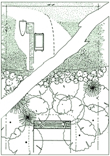
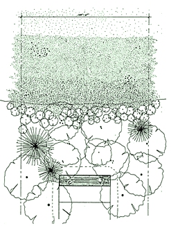
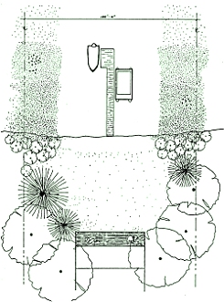
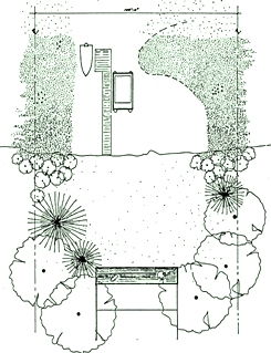
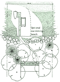
You can change a natural wooded lot to improve lake access and lakeshore views from your cabins or homes without removing all natural vegetation (Figures 1, 2). Keeping cleared areas for docks and beaches to a minimum allows you to leave some aquatic vegetation to provide critical shoreline protection. Selectively removing branches, shrubs, and even trees to create desired lake views can minimize shoreland impacts. This selective vegetation removal is called shoreland editing. Shoreland editing is a stepby-step process dictated by your own needs and tastes. Effective editing is done over several seasons using this basic approach. First you create a map of the buildings, vegetation and other features of your property. Next you determine where to put the paths, beach, dock, and boat storage, and make these alterations removing as little vegetation as possible. After assessing views from all windows and doors in the home as well as from the lake to the home, you decide which trees, shrubs, and branches need to be removed to improve the views and tag them. You can work with an arborist or other competent including aquatic (in water) and upland tree trimmer to remove the tagged vegetation. Wait at least a month before deciding whether additional editing is necessary. Detailed Procedure
1. Creating a base map Sketch the features of your property on graph paper. Use a scale of I" = 16' for 8.5 x 11 " maps of sites with 100 feet of shoreline and a house 75 feet from the lake. If your property is much smaller, a scale of I " = 10' may work. The map does not need to be perfect, just approximate, but should include the following:
On the base map, sketch to scale your proposed path(s), dock, and beach.
You can create paths and add a dock and a beach before or after editing. If you remove some trees and shrubs when adding these elements, less vegetation will need to be removed later. On the, other hand, after editing trees or shrubs to create views, it can be easier to spot a "natural" walk to the shoreline with a logical place for a dock.
3. Improving lake views Make notes on your map for desired viewing areas of your home. These notes should include which trees, shrubs, or branches might be best removed to allow views from that area. - If there is some-thing specific you want to see from a certain view, like a dock or nest, write this down as well. Don't forget to view the shoreline from the water to assess how removing trees, shrubs, and branches will affect protection from wind and the appearance of your property. After identifying on the map trees, shrubs, and branches for removal, locate them on the ground. Tag them with brightly colored landscaping tape to mark them for removal. If you have a choice of removing one of a group of trees or shrubs, take out the fastest-growing species or less-healthy specimens. Consider leaving some dead standing trees as long as they are not a safety threat. These "critter trees" provide excellent wildlife habitat. The next step is to remove the tagged trees, shrubs, and branches. The best season for editing depends on the species to be removed. Some trees, such as oaks and elms, should not be pruned in April, May or June. It is not feasible for many shoreland owners to remove trees themselves. You may want to call a professional arborist or request assistance from someone you know with tree removal experience. When hiring a professional, be clear about what you don't want removed. Let branches, trees, and shrubs lie where they fall, unless they block travel paths or are in maintained lawn. They provide needed habitat for wildlife and help stabilize the shoreline. Trees and branches that fall in the water provide excellent habitat for many fish. If more than one tree has been tagged, remove one tree at a time. Reassess the views from your home after each removal to be sure the other trees still need to be removed. In some cases, removing a branch rather than a whole tree may complete the editing. Remember to consider seasonal differences: in the winter leafless trees will not provide as much privacy. Too much editing of thick summer growth may leave your house exposed during much of the year. If you are unsure whether to remove something, leave it and reconsider removal in a few months or in a different season. After completing several edits, you should attain the desired views with minimal loss of vegetation. Taking pictures before and after editing can provide you with a history of progress toward your goals. You likely will want to do routine editing every few years, as trees and shrubs continue to grow. For lowering yard maintenance, protecting water quality, reducing erosion, and sustaining habitat, shoreland editing is a viable method of property development. 1. Natural Shoreland Landscaping
Project Manager: Roxanne Madison This series of publications is a result of a research project funded by the Minnesota Pollution Control Agency. Principal investigator for the project was Susan Galatowitsch, Assistant Professor, UM Departments of Horticultural Science and Landscape Architecture. Local coordinator for the project was Jean Pitt, Extension Educator, Aitkin County. |
| Back |
![]()
Produced by Communication and Educational Technology Services, University of Minnesota Extension Service.
In accordance with the Americans with Disabilities Act, this material is available in alternative formats upon request. Please contact your University of Minnesota Extension Service office or the Distribution Center at (800) 876-8636.
The University of Minnesota Extension Service is committed to the policy that all persons shall have equal access to its programs, facilities, and employment without regard to race, color, creed, religion, national origin, sex, age, marital status, disability, public assistance status, veteran status, or sexual orientation.